About Me

My photo
When? Started: 1993 Who? Started with staff and friends from U H S, Chester. Organiser: Martyn Harris We walk every Wednesday and Saturdays, New Years day and May Day. How many walk? Walks take place as long as there are at least 2 wanting to walk on that day. More walk on a Wednesday than on a Saturday. Most ever: 29. Current group size walking: 2-10 in mid-week and 2-4 on Saturday. Where do we walk? Saturday: Anywhere in North and Mid-Wales, Peak District, Shropshire and the Long Mynd and as far North as the Trough of Bowland. Thursday: Anywhere within about 40 miles of Chester. Type of walk: Distance: 6 – 14 miles (but usually under 10 miles). Climb: up to 4000’ (but usually very much less!). People involved on walks in 2020:- Martyn Harris, Fran Murphy, Sue and Michel Pelissier, Mike Dodd, David Savage, Wendy Peers, Celia de Mengle, Wendy and Ian Peers, Roger Smith, Paul Collinson, Ed Meads, Nigel and Elaine Taylor, Celia de Mengle, Sue Pearson.

Saturday 30 March 2024

Raeadre Fawr, Raeadre Fach (Aber Falls) and More 30th March 2024

Crossing t6he Afon Aber for the first time.
The Afon Aber from the footbridge.
Our first view of Rhaeadre Fawr.
 Rhaeadre Fawr.
Rhaeadre Fawr.
About to crossthe Afon Aber for the second time.
Rhaeadre-fawr. from the wst side.
The Penmon Lighthouse from the North Wales Path between Rhaeadre-fawr and Rhaeadre-fach.
Rhaeadre-fach.
The way ahead on the North Wales Path.
Rhaeadre-fawr and Rhaeadre-fach from the North Wales Path.
Lamb on the run.
The view from our lunch spot.
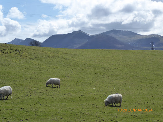
The high tops of the Carneddau - some with snow.
The quiet country lane leading to Crymlyn.
A good display of flowering gorse.
Ewes on the lower slopes with two lambs.
Walk Stats:
Distance: 9.6 miles. Climb: 1365’ (Possibly wind assisted GPS reading).
Time: 5 hours 5 minutes.
On the move walking average: 2.4 m.p.h.
Overall walk average: 1.9 m.p.h.
Temperature: 6.6 – 17.4 Celsius
Beaufort Wind Force: 4, a Moderate breeze as we headed along the North Wales Path at the highest point of our walk.
Group: Martyn and Ed.
The weather forecast today was really good, but and this brought out lots of others that wanted to take advantage of the forecasted warm and sunny day. Arriving at Abergwyngregyn, we just about got the final parking spot!
We have never seen so many cars parked at Abergwyngregyn and around the higher parking area used for visiting Aber Falls.
All the way to the falls there was a steady stream of people – good to see lots of families out as well.
Arriving at Rhaeadre-fawr it wasn’t easy to take a photo without people being in it as well.
Rhaeadre-fawr was pretty impressive today with lots of water crashing down. Near the falls, the temperature dropped to 6.6 Celsius, when the rest of the walk we experience temperatures above 10 Celsius.
Once on the west side of the valley we escaped from the main tourists and had much of the route to ourselves, seeing one walker, one runner and a farmer out checking his sheep.
It was good to see so many lambs on the hills.
Lunch was taken on the side of the North Wales Path, with good views towards Anglesey and Puffin Island. It was a good sheltered spot in the Sun.
Part of the route after lunch involved using a pleasant minor road that gave good views towards the coast and Llanfairfechan.
Arriving back at the car, even more cars had parked up, many of them in places that weren’t appropriate!
Birds seen or heard today included: Carrion crow, Jackdaw, European robin, Common blackbird, Blue tit, Common buzzard), Common chaffinch, Wood nuthatch, House sparrow, Song thrush, Common chaffinch, Wheatear, Meadow pipit, Woodpigeon and Skylark.
Overall a very enjoyable walk – a one shirt one handkerchief day, a testimony to the perfect weather for walking experienced today.

Wednesday 27 March 2024

Nant-y-Pandy and More 27th March 2024

The Village Hall at Glyndyrdwy with its links to Owain Glyndwr.
Nant-y-Pandy at the start of the walk.
The first waterfall on Nant-y-Pandy.
The second waterfall on Nant-y-Pandy.
Looking across the Dee Valley towards the Llantysilion Mountains and the Eglwyseg Escarpments.
Our first sighting of a young lamb on our walk today.

Looking across Nan-y-Pandy towards the Deeside Quarry.
Waiting to head across open moorland.
Moel Fferna in the distance - about as near as I wanted to get today!
Our lunch spot, a resting place for Lekis in the past!
We can all go home happy - we've seen Mo;le Famau!
Another view looking across the Dee Valley towards the Llantysilion Mountains and the Eglwyseg Escarpments.
Walking down the road in a hail storm.
Walking away after a good drink!
Walk Stats:
Distance: 8.2 miles. Climb: 1519’ (Possibly wind assisted GPS reading).
Time: 4 hours 34 minutes.
On the move walking average: 2.4 m.p.h.
Overall walk average: 1.8 m.p.h.
Temperature: 6.6 – 8.7 Celsius
Beaufort Wind Force: 3, just a Gentle breeze, although at times it felt a little more than that!
Group: Martyn, Nigel, Mike and Ed.
The weather forecast today wasn’t brilliant, but we were all determined to walk even if it was raining all day.
Thankfully it wasn’t, a little rain as we set off, a hail shower towards the end and the worst rain briefly as we walked back to the cars along the A5.
The path along the West side of Nant-y-Pandy is always good, but today the extra volume of water flow made the waterfalls look even better.
We even managed to find our way across the open moorland without any hassle and arrived at our lunch spot by a small wood.
After lunch all of us decide that the Moel Fferna extension wasn’t desirable today, heading back to the cars quicker and heading for The Grouse Inn at Carrog was the better option,
Birds seen or heard today included: Carrion crow, European robin, Common blackbird, Blue tit, Common buzzard (Seen when enjoying a pint at the Sun at Trevor), Common chaffinch, Wood nuthatch, Common chaffinch, Winter wren, Green woodpecker and Common pheasant.
Overall a very enjoyable walk, especially as by the time I had finished changing, the rain had stopped and I was in bright warm sunshine again.
We arrived at the Grouse Inn at Carrog, looking forward to our usual excellent pint of Lees bitter. Alas we were disappointed, they had no real ale, and delivery was expected tomorrow!
We ended up at The Sun a Trevor, where we had two excellent pints of real ale.

Thursday 21 March 2024

Walk and Dates March 2024


 Latest Information About Harris Hikers from 23rd March 2023.
After much discussion between group members, those present decided to follow DS’s suggestion that “Short walks with an. option of a meal at a nearby venue” should take place on the fifth Wednesday in a month, and members of the group would take it in turns to plan the walk and venue.
There are three such Wednesdays left in 2024. 
.These are:- May 29th, July 31st, and  October 30th.
It was also agreed that Wednesday Walks should in the main be walks of around 8 miles with no more than about 1200’ of climb. If proposed walks exceed these suggestions routes should have obvious short cuts to reduce distance and / or climb involved.
It was also agreed that each month a different member of the group should plan the walk.
This walk should be for the Wednesday in the month and that would include the “Short Walk and Meal Option” on the fifth Wednesday.
In order to include that walk in the monthly “Dates and Walks Post", details of the walk need to be sent to me by 15th of the previous month.
Wherever possible I would like people to let me know of their intention to walk or not to walk by Monday afternoon/early evening prior to the walk on Wednesday. There isn’t an issue with last minute cancellations for any reason. This happens anyway when adverse weather is forecast at the last minute.
Where the “Short Walk and Meal” is concerned, the person planning the walk and meal should
be contacted directly and informed of their intentions as soon as you have made your decision.
Saturday 2nd March 2024.
Rhos-on-Sea, Bryn Euryn and Coed Pwllcrochan.
Distance: 10-11 miles. Climb: 1800'.
Start: Roadside parking on Marine Drive in Rhos-on-Sea, near to St., Trillo's Church.
Grid ref: SH841811.
It may may be better to park in Trillo Avenue, opposite the church.
Leave Chester at 08-30.
Those planning to walk: Martyn, Mike, Ed.
Those not walking: 
This walk combines three walks from Dave Berry's book "Walks Around Llandudno and
Prestatyn".
One is described as a varied walk exploring the hinterland behind Rhos-on-Sea and
includes the hillfort in Bryn Euryn Nature Reserve. The other walk offers panoramic views as
it meanders through the undulating countryside bordering on Mochdre, Colwyn Bay and
Rhos-on-Sea.
Wednesday 6th March 2024.
Abergele and Moelfre Isaf.
Distance: 9.0 miles. Climb:1250'.
Start: Pensarn Beach Car Park. Grid ref: SH944787. Park near the PC block as we will be heading South towards the centre of Abergele.
Leave Chester at 09-00 a.m.
Those planning to walk: Martyn, Mike, Fran, Ed?.
Those not walking: Sue and Michel, Nigel.
Abergele and Moelfre Isaf.This walk is by Debbie Hamelton and starts in the centre of Abergele, but we will start on the coast. This will extend the walk by about 2 miles. The main walk is described as exploring the beautiful North Wales countyside South of Abergele. The outward route passes a well preserved watch tower. The last time we did this walk in March 2019 and it was a little on the breezy side Hopefully the weather will be kinder to us this time.
Saturday 9th March 2024.
The Swallow Falls, Cyffty Mine and More.
Postponed due to a bad weather forecast.
Alternative walk. 
A walk from Chester Railway Station starting at 11-00.
Distance: 8 - 9 miles; Climb:1500'.
Start: Betws-y-coed Station (Long Stay) Car Park (Pay and Display £5-00?) Grid ref: SH792567
Leave Chester 08-30 a.m.
Those planning to walk: Martyn, . 
Those not walking: Mike .
This walk uses part of a walk from Dave Berry's book "Walks Around Betws-y-coed and The Conwy Valley" with an extension takes us into part of the Gwydir Forest, with the return route following the Afon Llugwy riverside path from the Miners' Bridge  back to Betws-y-coed.
Wednesday 13th March 2024.
Above Helsby and Frodsham.
Distance: 7-8 miles. Climb; 1000'.
Start: Helsby Quarry Woodland Car Park. Grid ref: SJ490750 Post code: WA6 9PT
Leave Chester at 09-00 a.m.
Those planning to walk: Martyn, .
Those not walking: Sue and Michel.
This walk is taken from the book "Pathfinder Guide to Cheshire". Much of it we have done before when following walks on the Sandstone Trail. However part of the walk around Helsby Hill is new to me and it is the first time that we have started from this car park. On a clear day, the views across the estuary is superb. The walk is described as being energetic. As the walk is a little shorter than usual, we may wish to explore the Woodhouse Hill fort a little more.
Saturday 16th March 2024.
Llanrwst, Llyn Geirionydd, Llyn Crafnant and Trefriw.
Postponed - Ed informs me that there has been flooding in the Llanrwst / Trefriew Area.
Ed has suggested that we do the Swallow Falls Walk originally planned for 9th March 2024.
This is probably a good option, weather permitting.
Unfortunately weather forecasts suggest 50-70% chance of rain for most of the day.
Unless the forecast changes significantly for the better, it looks like I will be staying at home. 
Distance: 10 miles; Climb:1561'.
Start:Llanrwst Plas yn Dre car park. Grid ref:SH796618
Leave Chester 08-30 a.m.
Those planning to walk: Martyn, . 
Those not walking: 
This is a walk devised by Ed, which we first did on 6th April 2019. Last time we took over 6 hours for the walk, but I'm sure Ed will find a short cut ot two if need be!
Wednesday 20th March 2024.
Coed-y-Felin, Moel Ffagnalt and Moel-y-Gaer.
Postponed due to a bad weather forecast.
Distance: 9-10 miles. Climb: 1400'.
Start: Coed-y-Felin, Hendre. Grid ref: SJ196678.
Leave Chester at 09-00.
Those planning to walk: Martyn, Mike . 
Those not walking: Sue and Michel, Fran, Nigel, Ed.
This walk combines two walks taken from Dave Berry's booklet " Walks Around Holywell and Halkyn Mountain.
It is a few years since we last walked from this from Coed-y-Felin, and this will be the first time we have done so on a Saturday.. The main walk explores the varied countryside between the Wheeler Valley and and Halkyn Mountain, whilst the extensions explores Moel Ffagnalt and the area around Rhes-y-cae.Weather pemitting we can expect good views from both Moel Ffagnallt and Moel-y-Gaer.
Saturday 23rd March 2024.
Bollington to Bowstones.
Postponed due to the weather - too wet and windy!
Distance: 9-10 miles.
Climb:1800' at a guess.
Start: Adlington Road, Car Park. Adlinton Road is on the north of Bollington, a left turn just off the B5090.
Grid ref: SJ93087802
Leave Chester at 08-30 a.m.
Those planning to walk: Martyn, .
Those not walking: .
This walk is taken from Graham Beech's book "East Cheshire Walks", and is the second walk from this book that we will undertake. He describes this walk as an exhilarating walk to the Bowstones, and is a popular walk. It includes a fair portion of Lyme Park and sections of the Gritstone Trail. He describes the walk as strenuous, but I think we can still cope, even though it is over fifteen years since we last dit it.
Wednesday 27th March 2024.
Moel Fferna and Nant-y-Pandy.
Distance: Including Moel Fferna. 9 miles. Climb: 2000’.
Distance: Without Moel Fferna 6.5 -7.5 miles depending on return route taken.
Climb: 1375' - 1600'. depending on return route taken.
Start: Lay-by adjacent to the former Butterfly Man Craft Centre on the A5 Llangollen to Corwen road
near Glyndyfrdwy. Grid ref:SJ1586942449.
Leave Chester 09-00 a.m.
Those planning to walk: Martyn, Mike, Nigel, Ed Fran?.
Those not walking: Sue and Michel.
The described part of the walk is taken from Dave Berry’s book “Walks Around Llangollen and
the Dee Valley”. He describes it as a fascinating walk through the wooded.
Nant-y-Pandy with its old slate works. The extension takes us to the summit of Moel Fferna,
in the past most of the group have left out the visit to the summit of Moel Fferna, but the option
is still there for those that do.
Saturday 30th March 2024.
Either
Pen y Benar 
followed by 
Dolwyddelan Village and Castle.
Postponed.
Distance:7-8 miles. Climb:1600'.
Start: Dolwyddelan Station Car Park. Grid ref: SH737522. 
Leave Chester:8-30 a.m.
Those planning to walk: Martyn, .
Those not walking: Mike.
This walk combines two walks from Michael Burnett's Booklet "Walks East of Snowdon.  From Dolwyddelan the walk climbs up the Afon Cwmpenamnen Valley as far as Tan y Bwlch using Sarn Helen,
the highest point of the walk, Pen y Banar is described as being a spectacular viewpoint.
The second walk explores Dolwyddelan Village, including visiting Dolwddelan Castle.
As this is a figure of eight walk, lunch will probably be taken at the picnic site next to Dolwyddelan Station car park.
Either
Carreg Alltrem and Ty'n y Cwm 
followed by 
Dolwyddelan Village and Castle.
Postponed.
Distance:7-8 miles. Climb:1200'.
Start: Dolwyddelan Station Car Park. Grid ref: SH737522. 
Leave Chester:8-30 a.m.
Those planning to walk: Martyn, .
Those not walking: Mike.
This walk combines two walks from Michael Burnett's Booklet "Walks East of Snowdon.
The first walk is described as a delightful walk taking you to the head of the deep sided Penamnen Valley. The return route follows Sarn Helen past the ancient settlement of Tyn y Cwm and Ty Penamnen.  At one point we should get good vews of the Maesgwm waterfall.
As this is a figure of eight walk, lunch will probably be taken at the picnic site next to Dolwyddelan Station car park.
Actual Walk.
Rhaeadre Fawr, Rhaeadre Fach (Aber Falls) and More 30th March 2024
Distance: 9-10 miles. Climb: 1400'.
Start: Abergwyngregyn Car Park. Grid ref: SH65657284.
Leave Chester:8-30 a.m.
Those planning to walk: Martyn, .
Those not walking: Mike.

Saturday 16 March 2024

Swallow Falls, Cyffyty Mine and More 16th March 2024

View from the footbridge at Betws-y-coed Station,
The Afon Llugwy from Pont-y-Pair.
The woodland path heading towards the Miners' Bridge.
the path from the Miners' Bridge - it seems easier going down!
I thought the Swallow Falls would be better than this!
The Swallow Falls - that's more like it!
The road bridge by the Ugly House ( Ty Hyll).
The view from our lunch spot at the Tynllwyn picnic site.
The Cyfftty Mine site - not explored today!
Heading for the leete.
I think we are on the leete now.
Rising vapour on the other side of the valley.
The deralict farm building where we went wrong!
Descending the yellow / blue path.
The train now leaving Betws-y-coed is for Llandudno.
Walk Stats:
Distance: 9.1 miles. Climb: 1414’.
Time: 5 hours 20 minutes.
On the move walking average: 2.4 m.p.h.
Overall walk average: 1.7 m.p.h.
Temperature: 7.8 – 12.2 Celsius
Beaufort Wind Force: 0-1, no more that the occasional Light air.
Group: Martyn, Mike and Ed.
The weather forecast today wasn’t brilliant and we had dampness in the air all day!
Ed suggested that we should try doing the walk in a clockwise direction for a change. All went well in the morning, we met a couple overlooking the Swallow Falls that were obviously celebrating a special occasion as they had a “glass” of Prosecco”.
Our first problem occurred as we approached the Ugly House, the steps up to the road were fenced off due to a partial collapse of the steps and wall. Not wanting to retrace our steps, we managed with care to climb the steps to the road.
Lunch was taken at Tynllwyn picnic site, where the views suggested the clouds were getting lower!
After lunch all went well, until we reached a known derelict farm building where we missed the path we wanted and everything from then on became a challenge and ending up with us using footpaths that I don’t particularly want to use ever again!
Birds seen or heard today included: Carrion crow, European robin, Common blackbird, Great tit, Blue tit, Common buzzard, Common chaffinch, Wood nuthatch and Pied wagtail.
Overall a very enjoyable walk that would have been much better if we had not missed a vital footpath next to a derelict building!
After walk drinks were enjoyed at the Blue Bell at Halkyn, where the Lees Bitter was excellent and the Ginger beer and Pipers Sweet Chilli Crisps went down well.

Wednesday 13 March 2024

Above Helsby and Frodsham Hills 13th March 2024

One of the three notices at the start of our walk.
The second notice at thye start of our walk today.
On the trail through Helsby Quarry.
On the way through Snidley Moor Wood to Shepherds Houses.
A male Pintail on the right, but not sure about the one on the left.
Time for a rest and drinks - elevensies!
"I haven't finished yet!"
The Sandstone Trail from the elevensies spot.
Looking across the River Mersey towards Liverpool Cathedrsl as we crossed the field towards Beacon Hill, Frodsham.
The view across the Mersey from Frosham Hill.
On the Sandstone Trail across Frodsham Hill.
Sandstone outcrops on Frodsham Hill.
Looking over Helsby from the Sandstone Trail near Woodhouse Hill.
Liverpool Cathedral from the Sandstone Trail near Woodhouse Hill.
Walk Stats:
Distance: 7.6 miles. Climb: 1339’.
Time: 4 hours 32 minutes.
On the move walking average: 2.3 m.p.h.
Overall walk average: 1.7 m.p.h.
Temperature: 11.1 – 13.7 Celsius
Beaufort Wind Force: 2 – 3, mainly just a Light breeze, but around Memorial on Frodsham Hill it increased to a Gentle
Group: Martyn, Ed, Nigel, Fran and Mike.
This was a last minute switch as the Frodsham area had a better forecast than Flintshire.
This was a good decision as we only experienced a few odd spots of rain.
This was a good varied walk with a fair bit of ups and downs and at times giving us good views across the Mersey.
The only downside to the walk was the paths through the woods around Frodsham and Helsby Hill that challenged us in our attemps to avoid sinking too deep in the mulch!
Lunch was taken at the Memorial on Frodsham Hill, where there were plenty of benches to suit our needs.
Birds seen or heard today included: Jackdaw, Carrion crow, Rook, European robin, Common blackbird, Great tit, Blue tit, Common buzzard, Wood nuthatch, Black billed magpie, Greenfinch, Woodpigeon, Winter wren, Pintail, Shoveler, Grey heron, Moorhen, Collared dove and Dunnock.
Overall a very enjoyable walk, that felt a lot longer than the 7.6 miles recorded!
After walk drinks were enjoyed at the White Lion at Alvanley, where all three Robinsons real on offer were sampled by the group. The pot of tea I had was the largest I have had to date. I gave up after 4 cups.